A successful emergency response is a team effort. But what happens when your team—first responders, non-profits, and citizen volunteers—can’t communicate effectively? They often use different systems, creating dangerous information gaps. This leaves leaders asking, “what tools support real-time incident mapping for public safety teams?” The answer is incident mapping software. These platforms act as a central hub, providing a common operational picture for everyone involved. By using these real-time incident mapping tools for public safety, you break down communication barriers, ensuring a coordinated, community-wide response where everyone is on the same page.
Thank you for reading this post, don't forget to install the free PubSafe mobile app and subscribe!
Key Takeaways
- Gain a clear, shared view of any situation: Public safety mapping software transforms complex data into a single, interactive map. This gives every responder, from command centers to volunteers, a real-time understanding of where help is needed, improving situational awareness and enabling faster decisions.
- Streamline coordination across all teams: The software acts as a central hub for managing people and resources, breaking down communication silos between different agencies, NGOs, and community groups. This unified approach ensures everyone works together efficiently, preventing duplicated efforts and saving valuable time.
- Turn response data into future preparedness: The information gathered during an emergency is a powerful tool for planning. By analyzing incident patterns, resource deployment, and response times, you can identify areas for improvement and build more effective strategies for the next event.
Foundational Concepts in Emergency Management
When you think of emergency management, you might picture flashing lights and first responders. While that’s a critical part, it’s only one piece of a much larger puzzle. Effective emergency management is a structured discipline built on core principles that help everyone—from professional agencies to community volunteers—work together. It’s about moving from a reactive stance to a proactive one. By grasping the lifecycle of a disaster and the language used to describe events, we can build stronger, more resilient communities prepared for whatever comes their way.
The Four Pillars: Mitigation, Preparedness, Response, and Recovery
The most common framework for the disaster lifecycle is the “four pillars.” These phases guide a community’s efforts before, during, and after a crisis. Mitigation involves taking action to prevent a disaster or reduce its impact, like enforcing stronger building codes. Preparedness is about getting ready by creating plans and training teams. The Response phase is the immediate action taken during an emergency, from search and rescue to providing medical aid. Finally, Recovery is the long-term process of rebuilding and returning the community to normalcy. Each pillar is essential for a complete strategy.
Beyond the Pillars: Addressing Model Limitations
While the four pillars provide a fantastic guide, it’s important to remember that they are a model, not a rigid set of rules. Real-world emergencies are messy and rarely follow a neat, linear path. For example, recovery efforts can begin while the response is still underway, and preparedness is a constant, ongoing activity, not a one-time task. These models help us organize our plans, but they aren’t a substitute for flexible, on-the-ground thinking. The most successful strategies recognize that these phases often overlap and require an adaptable approach to meet a community’s evolving needs.
Defining Key Events: Near-Miss, Incident, and Accident
To manage risks effectively, we need a common language to describe what’s happening. A near-miss is an event that could have caused harm but didn’t—a free lesson in what could go wrong. An incident is an unplanned event that causes a disruption but doesn’t lead to injury, like a temporary communications outage. An accident is an event that results in injury or property damage. By encouraging everyone to report these events on a shared platform, communities can gather valuable data. Tracking near-misses and incidents helps identify patterns and address dangers before they become accidents.
What Is Public Safety Mapping Software?
Public safety mapping software is a tool that places critical information onto a dynamic map, giving everyone involved in an emergency a clear, shared view of what’s happening. Think of it as a smart map for disaster response. Instead of relying on static charts or fragmented radio calls, teams can see real-time data visualized geographically. This technology helps public safety groups, NGOs, and community volunteers coordinate their efforts and make faster decisions. It transforms complex data into an easy-to-understand visual format, showing where help is needed most and how resources are being deployed on the ground.
See the Full Picture with Real-Time Data & GIS Mapping
At its core is Geographic Information System (GIS) technology, which layers different types of data onto a single map. What makes it so powerful for public safety is the integration of real-time information. This isn’t a static map; it’s a living document that updates constantly as new reports come in and conditions change. This dynamic capability allows teams to move from reacting to old information to proactively responding to the situation as it unfolds. You can see how PubSafe works by combining these features to create a common operational picture for everyone.
Gain a Clearer View of Any Incident
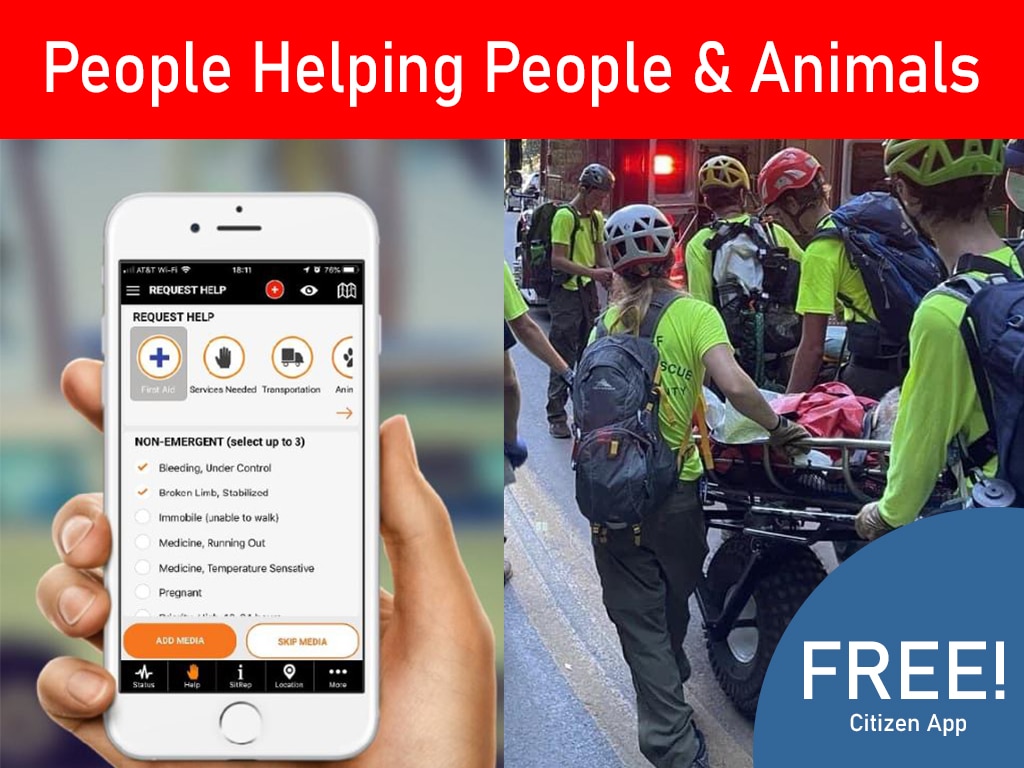
The primary goal of public safety mapping is to improve situational awareness, which means understanding the complete picture of an emergency. By layering data like incident reports and volunteer locations on a map, you can spot patterns and hidden dangers. For example, a search and rescue team can take geolocated photos of damage that instantly appear on the map for command centers to see. This allows leaders to prioritize response efforts effectively. Citizens can also contribute by reporting an incident from their phones, adding crucial on-the-ground information for first responders.
Connect Your Agency and Community Seamlessly
Emergencies require seamless teamwork between agencies, non-profits, and community volunteers. Mapping software acts as a central hub where everyone can share information securely, breaking down communication barriers so all teams work from the same playbook. This unified view prevents duplicated work and helps organizations coordinate plans together. When different groups see the same map, a fire department knows where a CERT team is, and an NGO can find a spot for a distribution point. This collaborative environment creates a more efficient and organized response, involving the entire community.
Why Use Public Safety Mapping Software?
When an emergency strikes, confusion is the enemy. Public safety mapping software cuts through the noise by providing a clear, shared view of the situation as it unfolds. It transforms complex, chaotic data into an interactive map that everyone from first responders to citizen volunteers can understand. This isn’t just about seeing dots on a screen; it’s about making faster, more informed decisions when every second counts.
The right platform helps you manage your people and equipment efficiently, ensures different agencies can work together without tripping over each other, and provides valuable data to help you prepare for future events. By centralizing information visually, you create a single source of truth that streamlines every aspect of a response. This technology is fundamental to a modern, coordinated emergency operation, turning data into decisive action. With a platform like PubSafe, you can see how all the pieces of a response fit together in one place, which is critical for effective team management.
Manage Resources and Volunteers with Ease
During a crisis, knowing what resources you have and where they are is half the battle. Mapping software gives you a real-time inventory of your personnel, vehicles, and supplies, all displayed on a live map. Instead of relying on messy spreadsheets or radio chatter, you can instantly see which volunteer team is closest to a reported incident or where your medical supplies are staged. This visual approach makes dispatching the right help to the right place much faster. It allows you to manage volunteer coordination during emergencies with precision, ensuring that skills and resources are deployed effectively instead of being wasted.
Coordinate Effortlessly Across Agencies
Emergencies rarely involve just one organization. Police, fire, NGOs, and community response teams often converge on the same scene, but they don’t always share the same information. This can lead to duplicated efforts and dangerous communication gaps. Public safety mapping software solves this by creating a common operational picture that all responding agencies can share. When everyone is looking at the same live map of incidents, road closures, and resource locations, collaboration becomes seamless. Different organizations can see what others are doing in real time, allowing for better support and a truly unified response. This is why getting every stakeholder on a single platform through organization registration is so important.
Turn Data into Proactive Plans
The value of mapping software doesn’t end when the emergency is over. Every incident reported, every volunteer dispatched, and every damage assessment logged creates a rich dataset. This information provides powerful insights for future planning. By analyzing post-incident data, you can identify patterns, such as areas most prone to flooding or neighborhoods with slower response times. This allows you to refine your emergency plans, allocate resources more strategically, and conduct more targeted training exercises. The data collected on the public map becomes a tool for building a more resilient community, helping you prepare for the next event with lessons learned from the last.
Supporting a Wide Range of Public Safety Industries
The power of public safety mapping software lies in its versatility. It’s not a niche tool for a single type of disaster; it’s a flexible platform that adapts to the needs of countless public safety sectors. From coordinating complex, multi-jurisdictional security operations to managing on-the-ground humanitarian relief efforts, the core principles remain the same: provide a clear, shared view to enable better, faster decisions. This technology serves as a common language for different industries, allowing them to work together seamlessly. Whether you’re tracking a wildfire’s spread or mapping out safe zones after a flood, the software provides the foundational situational awareness needed to protect lives and property effectively.
Emergency Communications and Homeland Security
In fields like emergency communications and homeland security, information is everything. Agencies at local, state, and federal levels must work in lockstep, but they often operate on separate systems. This is where mapping software becomes a game-changer. It acts as a central hub, creating a common operational picture that everyone can access. Instead of fragmented updates, all stakeholders see the same real-time map of incidents, resource deployments, and potential threats. This unified view breaks down communication barriers, ensuring that a police department in one city and a federal agency in another are perfectly aligned. This is essential for building a coordinated response to large-scale events where every second of synchronized action matters.
Humanitarian Assistance and Wildland Fire Management
The software’s adaptability shines in specialized fields like humanitarian aid and wildland fire management. For NGOs, it means visually tracking aid distribution to ensure supplies reach the most vulnerable populations and avoiding duplicated efforts. In firefighting, GIS mapping uses up-to-the-minute information to make critical decisions quickly. Teams can overlay live data from weather sensors, drone footage, and ground crew reports to track a fire’s perimeter and predict its path. This allows incident commanders to deploy resources with precision and issue timely evacuation warnings. By integrating data from multiple sources, including citizen reports, organizations can manage complex operations with a level of clarity that was previously impossible.
The Incident Management Process: From Report to Resolution
An effective incident management process is more than just a checklist; it’s a structured framework that guides your team from the moment an incident is reported until it’s fully resolved and analyzed. This systematic approach ensures that nothing falls through the cracks, resources are used wisely, and every action is deliberate. It transforms a chaotic situation into a series of manageable steps: identification, prioritization, response, and resolution. A well-defined process empowers every team member, from field volunteers to command staff, to act confidently and cohesively, knowing they are part of a coordinated effort.
Modern incident management relies on a central hub where information flows freely and is accessible to everyone who needs it. This is where a unified platform becomes indispensable. Instead of juggling radio calls, text messages, and emails, a system like PubSafe provides a single source of truth. It allows for the seamless flow of information, from a citizen who can report an incident on their phone to a team leader dispatching resources on a map. This integration is the backbone of a swift and organized response, ensuring that the process isn’t just a plan on paper but a dynamic, real-time operation.
Prioritizing Incidents for Effective Response
When multiple incidents occur at once, you face a critical question: where do you send help first? Prioritization is the art and science of answering that question effectively. It involves quickly assessing the severity, scope, and potential impact of each event to determine where your resources are needed most. This isn’t about guesswork; it’s about making data-driven decisions under pressure. A strong prioritization strategy ensures that the most critical needs are met immediately, saving lives and preventing a situation from escalating while managing less urgent issues concurrently.
The key to smart prioritization is situational awareness. The best way to achieve this is by visualizing all your incoming data on a single, interactive map. By layering information like incident reports, volunteer locations, and available resources, you can instantly see the bigger picture. This common operational picture helps you spot patterns, identify high-risk zones, and understand the relationships between different events. A platform that provides this view allows you to move beyond reacting to the loudest call for help and start making strategic choices that maximize the impact of your disaster response platform and team.
Root Cause Analysis: Finding the “Why” Behind an Incident
Closing an incident report doesn’t mean the work is done. The most resilient organizations know that the phase after the response is just as critical. Root cause analysis is the process of digging deeper to understand the fundamental reasons an incident occurred. It’s about moving past the immediate symptoms—like a flooded road or a localized power outage—to uncover the underlying cause. Was the drainage system overwhelmed due to a previously unknown vulnerability? Did a communication breakdown delay the response? Answering these questions is essential for long-term improvement.
The information gathered during an emergency is a goldmine for future planning. Every report logged, every resource deployed, and every timeline tracked creates a detailed record of the event. By analyzing this data, you can identify systemic weaknesses and areas for improvement. For example, reviewing incident patterns on a public map might reveal a neighborhood that is consistently hit hardest. This insight allows you to develop more effective mitigation strategies, refine your response plans, and build a stronger, more prepared community for the next event.
The Role of Regular Training and Compliance
A brilliant incident management plan is only effective if your team knows how to execute it. Regular training is the bridge between strategy and action. It ensures that every staff member and volunteer, from veterans to new recruits, is familiar with their roles, the protocols, and the tools they’ll be using. Drills and exercises build muscle memory, so when a real crisis hits, people can act decisively without hesitation. Consistent training keeps your team sharp, adaptable, and prepared for the evolving nature of risks, ensuring everyone is ready to perform their best under pressure.
Beyond operational readiness, training is also fundamental to maintaining compliance with industry standards and legal regulations. A well-documented training program demonstrates a commitment to safety and professionalism, which is crucial for public trust and legal protection. When your entire team is trained on a unified system, it ensures that everyone is following the same procedures for communication, data entry, and volunteer coordination. This standardized approach not only improves efficiency but also guarantees that all actions are documented correctly, creating an accurate and defensible record of the response.
Meeting OSHA Reporting Deadlines
For organizations with employees or official volunteers, compliance isn’t just a best practice—it’s a legal requirement with strict deadlines. The Occupational Safety and Health Administration (OSHA), for example, has rigid timelines for reporting workplace incidents. According to OSHA regulations, any employee fatality must be reported within eight hours, and any severe injury, such as an amputation or hospitalization, must be reported within 24 hours. Missing these deadlines can result in significant penalties and damage to your organization’s reputation.
An integrated incident management system is your best defense against non-compliance. When an injury is logged directly into a platform from the field, an automated workflow can be triggered. The system can instantly notify the safety manager and other key personnel, ensuring the reporting clock starts immediately. This removes the risk of delays caused by manual hand-offs or lost paperwork. Having a clear, time-stamped record of the incident and the subsequent report provides an unimpeachable audit trail, proving due diligence and protecting your organization.
How Public Safety Teams Use Real-Time Incident Mapping Tools
Seeing how public safety mapping software works in theory is one thing, but its real value shines when you see it in action. From coordinating live emergency responses to planning for future events, this technology is a game-changer for agencies, volunteers, and the communities they serve. Let’s look at a few ways you can put mapping software to work.
Coordinate Emergency Response in Real Time
During an emergency, every second counts. Mapping software provides a live, dynamic view of the situation, allowing teams to make faster, more informed decisions. For example, some agencies use geographic information system (GIS) technology to access thousands of camera feeds and building floor plans, helping them coordinate resource support for emergencies in real time. This level of detail means responders know what they’re walking into before they even arrive.
Real-time tracking of personnel is another critical feature. During hurricane response efforts, teams have used platforms to monitor team locations down to the individual device. This continuous monitoring not only improves efficiency but also dramatically increases the safety of everyone in the field. With a platform like PubSafe, everyone from dispatch to on-the-ground teams can view the same public map, ensuring a unified and immediate response.
Deploy Volunteers and Resources Where They’re Needed Most
A successful response depends on getting the right people and supplies to the right places. Mapping software acts as a central command center for logistics. Instead of relying on spreadsheets and radio chatter, you can visualize where your assets are and deploy them with precision. This is crucial for everything from dispatching ambulances to organizing community-led efforts.
Effective volunteer coordination is one of the biggest challenges in a disaster. A mapping platform helps you see where help is needed most and direct volunteers accordingly. You can track team assignments, monitor progress, and reallocate resources as the situation changes. This ensures that your team’s efforts have the greatest possible impact without duplicating work or leaving gaps in coverage.
Keep Your Community Informed and Safe
Public safety isn’t just for official responders; it involves the entire community. Mapping software can bridge the gap between agencies and the public by providing clear, accessible information. Many agencies now use data portals to share updates, helping residents understand risks and make safe decisions. This transparency builds trust and turns citizens into active partners in their own safety.
This technology can also empower people with critical knowledge before an incident occurs. For instance, agencies can use indoor maps to create virtual walkthroughs of public buildings, identify potential chokepoints, and share planned evacuation routes. On the PubSafe platform, citizens can take an active role by reporting an incident directly through the app, adding vital, on-the-ground information to the shared map for everyone to see.
Use Incident Data to Plan for the Future
The work isn’t over when the emergency ends. The data collected by mapping software is an invaluable resource for after-action reviews and future planning. Instead of spending weeks compiling manual reports, you can instantly access a geographic and chronological record of the entire event. Teams can use geolocated photos and incident reports to conduct detailed damage assessments and understand what happened, where it happened, and why.
Analyzing this data helps you identify patterns and find opportunities for improvement. You might discover that certain neighborhoods had a slower response time or that a specific resource was underutilized. These insights allow you to refine your emergency plans, adjust training protocols, and build a more resilient disaster response platform for the future. It’s about learning from every event to ensure you’re even better prepared for the next one.
Specific Applications in Law Enforcement
Beyond large-scale disaster response, mapping software offers powerful tools for day-to-day law enforcement operations. By turning data into visual intelligence, it helps officers on the street and analysts in the office work more effectively to keep communities safe.
In-Car Officer Support
Imagine an officer responding to a call, but instead of just a voice on the radio, they have a live map in their vehicle showing the incident location, nearby units, and historical data for that address. This technology doesn’t replace traditional police work; it enhances it. GIS helps police use their crime data more effectively, providing critical context that can make all the difference during a patrol. Officers can see recent activity in the area, known hazards, or even access building layouts before they step out of their car. This level of in-field intelligence supports safer, more informed decision-making on the ground, where it matters most.
Crime Pattern Analysis
Back at the station, analysts use mapping software to see the bigger picture. By layering different datasets, they can uncover hidden crime patterns that would be impossible to spot in a spreadsheet. For example, the software can map where and when certain crimes occur, the types of weapons used, and even victim demographics. When this information is viewed alongside neighborhood features like parks, bars, or vacant buildings, analysts can start to understand the root causes of crime hotspots. This analytical approach allows departments to move from a reactive stance to a proactive one, deploying resources strategically to prevent crime before it happens.
Tracking Offenders and Protecting Victims
Public safety mapping is also a critical tool for protecting vulnerable members of the community. For instance, law enforcement agencies use it to manage and monitor registered offenders. By mapping where offenders live in relation to sensitive locations like schools, daycares, and parks, departments can ensure compliance with residency restrictions. They can even create digital ‘buffer zones’ around these locations to automatically flag any potential violations. This proactive monitoring helps agencies protect communities and provides peace of mind for residents, turning static data into an active shield for public safety.
The Future of Public Safety: Advanced Mapping Technologies
Public safety mapping is already transforming how we handle emergencies, but the technology is evolving faster than ever. We’re moving beyond just plotting points on a map and entering an era where our environment itself can communicate with responders. The next wave of innovation involves integrating data from smart devices, mapping indoor spaces with precision, and using drones and artificial intelligence to see and predict events before they escalate. These advancements promise to give first responders, organizations, and volunteers an even clearer picture of what’s happening, allowing for a response that is not just reactive, but proactive and incredibly intelligent.
“Smart” Emergency Response with IoT Data
The world is full of connected devices, often called the Internet of Things (IoT), and they are becoming our silent, digital first responders. Think about it: a smart smoke detector that alerts the fire department automatically, a vehicle that reports its own crash location, or a health tracker that signals a fall. This is the future of “smart” emergency response. Instead of waiting for a 911 call, response teams can receive real-time data directly from these devices. When this information is fed into a mapping platform, it provides an immediate, verified location of an incident, giving teams a critical head start. This is a natural extension of what platforms like PubSafe already do by allowing citizens to report an incident from their phones, creating a network of human sensors.
Indoor Mapping for Complex Environments
GPS is fantastic for getting you to an address, but its signal disappears the moment you step inside a large building like a school, hospital, or shopping mall. This is a huge challenge for first responders who need to move quickly and safely through unfamiliar, complex environments. Indoor mapping technology solves this problem by providing detailed digital floor plans directly to responders’ devices. These maps can show the location of exits, stairwells, fire extinguishers, and even life-saving equipment like AEDs. According to experts at GeoComm, this level of detail is crucial because just knowing an address isn’t enough. Having a clear layout before entry saves precious time and helps keep responders safe.
Drones as First Responders for Situational Awareness
Imagine having eyes in the sky that can reach an emergency scene before ground crews even get there. That’s the power of drones in public safety. These unmanned aerial vehicles can be deployed rapidly to provide a live video feed of a developing situation, from a spreading wildfire to a search and rescue operation in a remote area. This real-time aerial view gives command centers and field teams invaluable situational awareness. They can assess the scale of an incident, identify hazards, and locate victims without putting responders in harm’s way. This video data can be layered onto a shared map, like the PubSafe public map, giving every stakeholder a bird’s-eye view and enabling smarter, safer strategic decisions.
The Role of Artificial Intelligence (AI) in Incident Prediction
Artificial intelligence is moving from theory to practice in emergency management, primarily by helping us predict where incidents are most likely to occur. By analyzing massive datasets—including historical incident reports, weather patterns, traffic data, and social media chatter—AI can identify high-risk areas before a disaster strikes. For example, it could forecast which neighborhoods are most vulnerable to flash flooding during a heavy storm, allowing agencies to pre-position resources and issue targeted warnings. However, AI is only as good as the data it’s fed. It requires clean, organized, and accurate location data to make useful predictions. A robust disaster response platform that consistently gathers this type of information is the foundation for building a truly predictive and proactive public safety system.
How to Choose the Right Incident Mapping Software
Selecting the right mapping software is a critical decision that directly impacts your team’s effectiveness during an emergency. With so many options available, it’s easy to feel overwhelmed. To make the right choice for your organization and community, focus on four key areas: features and compatibility, budget, security, and ease of use. These factors will help you find a platform that truly supports your mission.
Match Features to Your Team’s Needs
In public safety, clear communication is everything. Yet, many agencies find themselves using a mix of different technologies that don’t work well together, making it nearly impossible for teams to communicate effectively. When evaluating software, look for a unified platform that can break down these silos. Your mapping tool should offer seamless team management and integrate easily with existing systems. The goal is to find a solution that connects every stakeholder, from dispatchers to field volunteers, on a single, reliable network. This ensures everyone has access to the same information at the same time, which is crucial when every second counts.
Find a Solution That Fits Your Budget
Funding can be a major hurdle for public safety organizations and non-profits. As one report notes, many groups “struggle to implement GIS solutions due to funding limitations.” It’s important to find a tool that fits your budget without sacrificing essential capabilities. Look for platforms with transparent pricing models. Some, like PubSafe, offer a free app for citizens and scalable solutions for organizations. This approach ensures that everyone in the community can participate in safety efforts, regardless of their budget. A good platform provides value by making professional-grade tools accessible to all who need them.
Ensure Your Data Stays Secure and Private
Public safety operations handle a lot of sensitive information, from incident details to personal data of volunteers and affected citizens. Because of this, data privacy is a top concern. The software you choose must have robust security measures to protect this data from unauthorized access or breaches. Vet each potential platform by asking about its security protocols, data encryption methods, and privacy policies. A trustworthy platform will be transparent about how it protects your data, giving you and your community peace of mind that your information is in safe hands.
Protecting Victim Anonymity in Data Visualization
Mapping data brings an incident to life, but it comes with a serious responsibility to protect the privacy of those involved. A precise pin on a map can inadvertently identify a victim’s home, turning a helpful tool into a privacy breach. This is why your software must include features for data anonymization. As government resources on crime mapping emphasize, it’s critical to protect people’s privacy by generalizing data—showing an incident’s location at the block or neighborhood level rather than a specific address. This approach strikes the right balance, giving responders the context they need for situational awareness without compromising personal safety. It ensures that any information shared, even on a public map, prioritizes the dignity and well-being of the community you serve.
Choose a Platform Your Team Will Actually Use
During a crisis, you don’t have time to wrestle with complicated software. A common challenge for teams is the difficulty in learning a new system. The right platform should be intuitive and straightforward for everyone, from seasoned emergency managers to first-time volunteers. Look for a clean interface, clear instructions, and simple processes for core tasks like reporting an incident. An easy-to-use platform reduces training time, minimizes errors, and empowers more people to contribute effectively. When the software is simple, your team can focus on what really matters: helping people.
Related Articles
- 4 Best Search And Rescue Dispatch Software (2026)
- Disaster Response Platform | Community‑Driven Emergency Coordination | PubSafe
- Government Emergency Management & Citizen Communication | PubSafe
- Government & NGO Citizen Safety & Communication Ecosystem
- Disaster Response Platform for Teams & Communities | PubSafe
Frequently Asked Questions
How is this different from a standard navigation app like Google Maps? While navigation apps are great for getting from one point to another, public safety mapping software is a dynamic command center. It layers real-time operational data, like incident reports, resource locations, and team statuses, onto a single shared map. It’s built for coordination among many groups, not just for travel, giving everyone a complete picture of an emergency as it unfolds.
Can smaller organizations or volunteer groups use this software? Absolutely. This technology isn’t just for large government agencies. Many platforms are designed to be scalable and accessible for non-profits, CERT teams, and other community groups. The goal is to create a unified network where organizations of any size can coordinate with each other and manage their own response efforts effectively.
How does this software keep my team and our data secure? Security is a fundamental requirement for any reputable platform. These systems use measures like data encryption and secure access controls to protect sensitive information, such as incident details or the personal data of volunteers. A trustworthy provider will be transparent about its security protocols, ensuring your operational and personal information remains protected.
What kind of training is needed to use this software effectively? The best platforms are designed to be intuitive, so you don’t need to be a tech expert to use them. While some advanced administrative features might require a brief tutorial, core functions like reporting an incident or viewing the map should be straightforward from the start. A user-friendly interface is key, as it allows your team to get up and running quickly with minimal downtime.
How does citizen reporting contribute to the overall response? Citizen reports provide real-time, on-the-ground intelligence that first responders might not have otherwise. When someone in the community reports an issue like a downed power line or localized flooding through an app, that information can appear instantly on the shared map. This helps officials verify incidents, identify emerging hotspots, and direct resources more accurately.
Look for Comprehensive Vendor Support
Great software is more than just code; it’s a partnership. When you choose a platform, you’re also choosing the team behind it. Look for a vendor that offers comprehensive support, including training and resources to get your team up and running smoothly. The best tools are designed to connect every stakeholder, from dispatchers to field volunteers, on a single, reliable network. Your vendor should be a partner in this mission, helping you integrate the software with your existing systems and ensuring it meets the unique needs of your community. A platform is only effective if it truly supports your team’s ability to manage a response from a unified command center.
Disaster Response Programs and Funding Assistance
Beyond day-to-day support, see what programs a vendor offers during a crisis. Some companies, like Esri, have a Disaster Response Program that provides immediate assistance during emergencies. This kind of support can be a lifeline when you need it most. Of course, funding is often a major hurdle, especially for non-profits and volunteer groups. Many organizations struggle to afford powerful GIS solutions. That’s why it’s essential to find a platform with a transparent and flexible pricing model that doesn’t lock essential features behind a high paywall. The goal is to find a solution that empowers your entire community, which is why getting your group set up through an organization registration process should be straightforward and accessible.