When a disaster strikes, a community’s greatest asset is its people. Everyone becomes a first-hand witness, seeing blocked roads, rising water, or neighbors in need of help. The challenge has always been how to collect this vital information and get it to the people who can act on it. This is where a modern crisis map becomes so essential. It transforms individual reports from citizens into a collective, real-time picture of the situation. By empowering everyone to contribute, we create a powerful tool that helps NGOs, CERT teams, and official responders direct resources exactly where they are needed most.
Thank you for reading this post, don't forget to install the free PubSafe mobile app and subscribe!

What is a Crisis Map?
A crisis map is the real-time collection and display of crisis or disaster data which enables faster and better decision making. A crisis map, or disaster map, is a key component to the governments response to a disaster but it is also critical for NGOs, CERTs and other volunteer organizations. A central crisis map enables multiple agencies and organizations to aid one another, coordinate, and support the overall effort with less communication and direction.
Scope and Purpose of Crisis Maps
Crisis maps are incredibly versatile tools that extend far beyond a single type of emergency. Their core purpose is to provide a clear, geographical picture of a situation as it unfolds, but their applications are diverse. They can be used to track the path of a hurricane, monitor the front lines of a conflict, or visualize the areas most in need of aid after an earthquake. By aggregating data from multiple sources—including satellite imagery, official reports, and even social media updates from people on the ground—these maps give response teams a dynamic and comprehensive view. This allows for better resource allocation, faster response times, and more effective communication between different groups working to manage the crisis.
Tracking Natural Disasters
When natural disasters like wildfires, floods, or hurricanes strike, situational awareness is everything. Crisis maps are essential for tracking the event’s progression and coordinating the response. For example, platforms like Google’s Crisis Response use advanced technology to help communities prepare for and react to these events. A shared map allows emergency managers to see where the damage is most severe, where resources are needed, and which evacuation routes are still open. This is also where community-powered platforms make a huge difference. With an app like PubSafe, citizens can report incidents like downed power lines or flooded roads, adding critical, real-time information directly to the map for everyone to see.
Tracking Global Conflicts
Beyond natural disasters, crisis maps are also vital tools for monitoring and understanding global conflicts. Organizations use interactive tools like the Global Conflict Tracker to provide detailed information about ongoing conflicts around the world. These maps can display data on everything from troop movements and territorial control to humanitarian corridors and refugee flows. For international aid organizations, NGOs, and peacekeeping forces, this information is indispensable. It helps them deliver aid safely, protect civilians, and make strategic decisions in highly volatile environments. A centralized map ensures that all stakeholders, from large government agencies to small volunteer teams, are working with the same operational picture.
Analyzing a Crisis’s Impact and Trend
A crisis map does more than just show what is happening at a single moment; it helps analyze the impact of a crisis over time and identify trends. By collecting data continuously, these maps can show the spread of a forest fire, the rate at which floodwaters are rising, or the areas most consistently affected by severe weather. According to the UN-SPIDER Knowledge Portal, this information is often updated in near-real time, which is crucial for predictive modeling and proactive decision-making. When organizations and citizens contribute to a shared platform, the resulting data provides a rich, layered view that helps leaders understand the full scope of a disaster and anticipate future needs, improving recovery efforts for everyone involved.
The Technology Behind Crisis Mapping
Crisis mapping has come a long way from pins on a physical map. Today, it’s a dynamic, data-driven field powered by some seriously impressive technology. These advancements allow us to see not just what’s happening right now, but what might happen next. By harnessing tools like artificial intelligence and satellite imagery, response teams can shift from a purely reactive posture to a more proactive one. This means anticipating needs, pre-positioning resources, and getting help to where it’s needed faster. It’s all about using technology to create a clear, shared understanding of a chaotic situation, which is the foundation of any effective disaster response and a core principle behind tools like the PubSafe public map.
Using Artificial Intelligence (AI) for Prediction
One of the most significant technological leaps is the use of artificial intelligence. AI algorithms can process massive amounts of data—like historical weather patterns, river levels, and topographical information—to predict where and when a disaster might strike. For example, Google uses AI to forecast the severity and timing of floods, giving communities and aid organizations critical lead time to prepare. This predictive power helps transform disaster management by enabling authorities to issue timely warnings and allocate resources before the crisis peaks, ultimately saving lives and property. It’s about turning data into foresight.
Using Satellite Data for Detection
Alongside prediction, rapid detection is crucial, and that’s where satellite technology shines. Satellites provide a bird’s-eye view, offering real-time information on developing events. Systems like FireSat are designed to detect wildfires almost as soon as they start, sending alerts that allow first responders to act before a small fire becomes an uncontrollable blaze. This data, from fire detection to floodwater mapping, is fed directly into crisis maps. This gives everyone from government agencies to on-the-ground volunteer teams a live, accurate picture of the situation. When you can see the full scope of an event as it unfolds, you can make smarter, faster decisions.
Phases of Crisis Management
Crisis management isn’t a single action but a continuous cycle with distinct phases. Understanding these stages helps organizations and communities prepare for, respond to, and recover from emergencies more effectively. A crisis map is a dynamic tool that proves invaluable across this entire lifecycle, evolving from a planning document to a live command center and finally to an analytical record. Each phase leverages the map’s data in a unique way to protect lives and property, ensuring a more coordinated and efficient effort from everyone involved, from first responders to citizen volunteers.
Preparedness: Getting Ready for a Crisis
The preparedness phase is all about the work you do before a disaster strikes. This is where you create plans, run drills, and position resources for a potential event. Technology plays a huge role here. For instance, Google’s Crisis Response initiative helps communities get ready for natural disasters by using advanced tech to model potential impacts. Similarly, a crisis map in this phase is a strategic tool. Emergency managers can use it to identify vulnerable populations, map out evacuation routes, and pre-designate locations for shelters or supply depots. For organizations, this is the time to get your teams organized and ready to deploy. A platform that allows for effective team management ensures that when a call goes out, everyone knows their role and where they need to be, turning a static plan into an actionable strategy.
Response: Staying Safe During a Crisis
When a crisis is happening, the response phase kicks in. This is a time of high-stakes action where clear, real-time information is critical. A crisis map becomes a living document, providing a common operational picture for everyone involved. As the UN-SPIDER Knowledge Portal notes, tools like the Google Crisis Map are vital during this phase, showing live data on everything from floods and wildfires to severe storms. This is where a community-powered platform truly shines. Citizens can report incidents like downed power lines or flooded roads directly to the map, while NGOs and CERT teams can see these reports instantly and direct resources where they are needed most. This shared awareness prevents duplicated efforts and helps responders address the most urgent needs first, creating a coordinated and efficient response that saves time and lives.
Recovery and Resilience: Rebuilding Stronger Communities
After the immediate danger has passed, the recovery phase begins. This stage focuses on rebuilding and restoring normalcy, but it’s also an opportunity to build back stronger. The data collected on the crisis map during the response is an invaluable asset for recovery efforts. It provides a detailed record of the event’s impact, helping with damage assessments and identifying areas that require long-term support. As Google highlights, technology like AI can be used to analyze this data to predict future events and improve community resilience. The information from the map helps planners understand what went right and what could be improved, informing future preparedness strategies. This data-driven approach ensures that the lessons learned from one crisis are used to better protect the community from the next one, creating a cycle of continuous improvement.
A Closer Look at the PubSafe Crisis Map
Think about the value of consolidating information across citizens, NGOs, and the government during a crisis. Image that information being in near real-time from hundreds or thousands of viewpoints or people. The potential impact is bigger than anything in years for the disaster management industry. PubSafe is unique in the data collected, how it is share, managed, and disseminated, and we are just getting started.
Accessibility and Features
The real power of a crisis map lies in its ability to gather and display real-time data, creating a single source of truth for everyone involved. This shared view is what allows different agencies and volunteer groups to coordinate efforts without getting their wires crossed. For example, tools like the Google Crisis Map provide layers showing specific hazards such as floods or wildfires, giving a clear picture of the immediate risks. PubSafe builds on this by creating a truly interactive and community-powered map. Any citizen can use the free app to report what they’re seeing on the ground, from a blocked road to a request for assistance. This information appears on the PubSafe public map, giving first responders and NGOs an invaluable, real-time view of community needs and allowing for more effective resource deployment.
How to Read the Crisis Map
The crisis map brings data from multiple sources together. The crisis map has even been integrated with telematics technology to track vehicles with GPS trackers installed from Geotab. Maps enable both a big picture understanding and the ability to drill down to specific user data efficiently and quickly. With global capabilities using OpenStreetMap, rescue teams can operate around the world and be monitored from a central dispatch center. Users can share visibility with all PubSafe users, just their organization, a team, or no one at all. Privacy and security is a top priority at all times.

Cancel outdated or expired posts by clicking the icon on the map or using the link in the email sent.
PubSafe Crisis Map
Review of the PubSafe Crisis Map features and functionality in the cloud portal.
Full Transcript of Video
This video is on how to use the PubSafe public safety community mobile app map. The first thing you want to do is select an event in the top left-hand corner by clicking on the green bar. That will bring up your settings menu from the dropdown menu. Select the particular event that is affecting your area. Scroll down and click save settings.
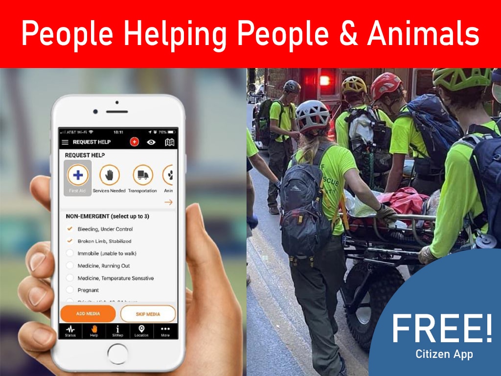
The information that you enter now will be associated with future research on how people move and operate during events. You’ll notice there are four icons in the lower right-hand corner of the map. The Q icon represents the quick menu which allows you to quickly add commonly used features. You can report information that is going on in your area as well as request help. The more information that is shared about what is going on the better the response the more efficient the response can be.
You can enter a help request which is for not emergency assistance And that may be something like needing water or clothes. or transportation? There is an active shooter feature which is an emergency of a particular type. And then you have a standard life and death emergency. Which may be a situation where your neighborhood is flooded and you are on the roof.
And you need rescue. If emergency services are watching the pub safe mobile app they will see your exact location on the map. And other users in the area will be alerted to your exact location in the nature of your emergency. And they may be able to respond faster than other. The next icon in the lower right-hand corner is the displayed label option where you can add and remove labels.
The next icon is the map filter option. You can clear all information from the map and add specifically what you want to see back to the map or you can search for a user on the map…
As you navigate around you’ll notice that there are different types of icons. We encourage people to enter hospitals as permanent locations in their particular area. You have a gray. silhouette which is a standard user and you have a star icon which is a responder. If you are in a responder status you are expected to be able to help others because you have particular skills or resources You can switch between these roles by using the more menu…
And as a responder you can change your mission status. You can be available to receive missions or you can go unavailable So you were not called upon to help others…
You can click the map icon in the top right-hand corner to return to the map at any time. The last icon in the lower right-hand corner represents your position You can click that icon in the map will recenter onto your position at any time. Your icon is always indicated. By the color black
…
In this example I just switched from being a responder to a citizen. As you navigate around the map. As you navigate around the map you will see clusters You can click on clusters to see the information within that cluster Or you can click on a particular icon and see the detailed information within you can also click on a user and see that user’s information…
Be sure to download and share the pub safe mobile app with family friends churches and communities. The more people we have on the pub safe mobile app the better the response will be. Get out there and take care of your neighbors in D safe
…
Get the PubSafe Mobile App

Frequently Asked Questions
How is a crisis map different from a standard navigation app? Think of a navigation app as a tool for getting from one point to another based on established roads. A crisis map, on the other hand, is a live, dynamic picture of a situation as it unfolds. It layers real-time information from many sources, such as citizen reports of flooded streets, official evacuation zones, and the location of emergency shelters, all onto one shared map. Its purpose is to provide situational awareness for everyone, not just directions for one person.
Can anyone contribute to the PubSafe crisis map, or is it just for official responders? Everyone is encouraged to contribute. While official responders and organizations use the map for high-level coordination, the system becomes truly powerful when citizens report what they see. Using the free PubSafe app, you can add reports about blocked roads, downed power lines, or even requests for assistance. This provides critical, on-the-ground information that helps responders understand community needs and direct their efforts more effectively.
How does the information on the map help after a disaster is over? The map becomes an invaluable historical record of the event. Once the immediate danger has passed, the data collected helps officials and organizations perform accurate damage assessments, showing exactly which areas were hit hardest. This information is also used to analyze the response, identify trends, and improve preparedness plans for the future, which helps communities build greater resilience.
Where does all the information on a crisis map come from? The data is a combination of information from several key places. It includes official alerts from government agencies, data from technologies like satellites that can detect wildfires, and real-time updates from people directly affected by the crisis. Platforms like PubSafe are designed to bring all these sources together to create a comprehensive and reliable view of the situation.
Is my personal information visible to everyone if I report an incident? Your privacy is a top priority, and you have control over what you share. The PubSafe platform allows you to choose the visibility of your reports and location. You can decide to share information publicly with all users, privately with just your organization or team, or not at all. This flexibility ensures you can contribute vital information while managing your personal data securely.
Key Takeaways
- Unify your response with a shared map: A crisis map breaks down communication barriers by creating a single, real-time view for citizens, NGOs, and official agencies. This shared picture ensures everyone is working with the same information, leading to faster, more coordinated aid.
- Shift from reactive to proactive with technology: Modern crisis maps use tools like AI for forecasting and satellite data for early detection. This allows response teams to anticipate needs and position resources before a crisis peaks, rather than just reacting after the fact.
- Use the map through every crisis phase: A crisis map is a powerful tool for the entire disaster lifecycle. Use it for strategic planning before an event, for live coordination during a response, and for data analysis afterward to build a more resilient community.
Related Articles
- Citizen Crowdsourcing for Disaster Response & Community Safety | PubSafe
- How Community Emergency Response Works | PubSafe Disaster Coordination Platform
- Crowdsourced Community For Citizen Safety: Help & Alerts
- PubSafe Can Be Used For Emergencies But Call 911 First
- Community Emergency Response Coordination Platform | PubSafe